Les Plans de Paris du XIXe et XXe siècle
Connexion
Déconnexion
connecté :
Accueil
Recherche
Insertion
auteur
par date
thématique
urbanisme
lien
contact
lire la fiche -
- modifier la fiche
le plan
Date :
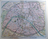
1893
Date supposée :
Date publication :
Auteur :
Bartholomew. John George
Titre :
Plan of Paris
Titre forgé :
plan of Paris
commentaire :
plan en couleurs tres simplifi�, indiquant seulement les axes principaux. les lignes de tramways sont en jaune, les chemin de fer en noir
description :
P. 30-31 de Bartholomew echelle de un mile anglais=2,7 cm
caractéristiques du plan
taille :
20 x 16 cm
echelle :
feuille :
1
echelle recalculée :
type du plan :
carte imprim�e
nature du plan :
Guide
prix à l achat :
orientation :
déformation :
rotation x :
0
rotation y :
0
ecart type :
0
position moyenne :
0
créateurs du plan
éditeur :
the edinburgh geographical institute
imprimeur :
lieu édition :
London
graveur :
écriture :
auttrait :
libraire :
topographie :
lithographie :
auteur ouvrage :
G. Philip
nom ouvrage :
The tourist's Atlas-guide to the continent of Europe
source et localisation
source :
BnF
web source :
inv. source :
Typo I :
872
inv. Boutier :
0
Typo II :
C
inv. Vallée :
202
genre :
inv. BnF :
GE FF- 2891 (30-31)
stockage :
Richelieu - Cartes et plans -
inv. BHVP :
support :
Carte
notice :
12/12/2013
support II :
longévité, copie et filiation
longévité : début
- fin
1893
duree de vie :
filiation :
copie :
reprise :
possession :
0
urbanisme
MONUMENTS;MUSEE;FONTAINES;AUTOBUS;METRO;GARE;PORT;FORTIFICATION;BARRIERE;CASERNE;MILITAIRE;ADMINISTRATION;PRISON;PALAIS;USINE;EGLISE;SANTE;BOIS;JARDIN;SQUARE;ALLEE;PARC;PONT;PLACE;QUAI;MARCHE;CIMETIERE;
information autour du plan
nom rue
index monument
nomenclature
vignette
plan situation
iconographie
contexte historique
contexte archéologique
autre localisation
Plan du même auteur
Plan avec le même titre
Plan of Paris
1858
Bradshaw
Princeton University
40 x 33 cm
Plan of Paris
1860
Bradshaw, George
Getty Research Institute
Plan of Paris
1868
Bradshaw
internet
46 X 68cm
Plan of Paris
1869
Bradshaw
Harvard University
Plan of Paris
1880
Gaze, Edwin W
internet
Plan of Paris
1881
Gaze, Edwin W
internet
Plan of Paris
1882
Bradshaw, George
University of Virginia
Plan of paris
1884
Baedeker, Karl
internet
Plan of Paris
1887
Gaze, Edwin W
internet
Plan of Paris
1888
Baedeker, Karl
biblioserver
1 map : col. 45 x 59 cm.(Scale 1:20.000) + 5 map
Plan of Paris
1896
Bradshaw
Bnf-Tolbiac
Plan of Paris
1898-1899
TRINQUIER, Louis
internet
16" x 20"
Plan of Paris
1898-1899
TRINQUIER, Louis
Cincinati library
40 x 25 cm
Plan of Paris
1898-1899
TRINQUIER, Louis
HathiTrust Digital Library
40 x 25 cm
Plan of Paris
1898-1899
TRINQUIER, Louis
British Library
40 x 25 cm
Plan of paris
1907
Meyer, Frederic
internet