Les Plans de Paris du XIXe et XXe siècle
Connexion
Déconnexion
connecté :
Accueil
Recherche
Insertion
auteur
par date
thématique
urbanisme
lien
contact
lire la fiche -
- modifier la fiche
le plan
Date :
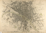
1834
Date supposée :
Date publication :
Auteur :
Clarke, W.B.
Titre :
WESTERN DIVISION OF PARIS CONTAINING THE QUARTIERS.
Titre forgé :
commentaire :
APRIL 1ST. PART HAND COLOR. STEEL ENGRAVING. Detailed plan of Paris with outlines of major landmarks along the bottom margin. Browned and a little fragile. S.D.U.K. maps are rare in folio this one is the two plans for the west and eastern divisions joined together.
description :
caractéristiques du plan
taille :
52 x 40 cm
echelle :
16000
feuille :
1
echelle recalculée :
15600
type du plan :
nature du plan :
prix à l achat :
orientation :
1
déformation :
rotation x :
1
rotation y :
1
ecart type :
43
position moyenne :
62
créateurs du plan
éditeur :
BALDWIN & CRADOCK
imprimeur :
lieu édition :
LONDON
graveur :
écriture :
auttrait :
libraire :
topographie :
lithographie :
auteur ouvrage :
nom ouvrage :
source et localisation
source :
Murray Hudson
web source :
inv. source :
Typo I :
484a
inv. Boutier :
0
Typo II :
A
inv. Vallée :
genre :
inv. BnF :
stockage :
inv. BHVP :
support :
notice :
support II :
longévité, copie et filiation
longévité : début
- fin
1850
duree de vie :
filiation :
copie :
reprise :
possession :
0
urbanisme
MONUMENTS;MUSEE;FONTAINES;AUTOBUS;METRO;GARE;PORT;FORTIFICATION;BARRIERE;CASERNE;MILITAIRE;ADMINISTRATION;PRISON;PALAIS;USINE;EGLISE;SANTE;BOIS;JARDIN;SQUARE;ALLEE;PARC;PONT;PLACE;QUAI;MARCHE;CIMETIERE;
information autour du plan
nom rue
index monument
nomenclature
vignette
plan situation
iconographie
contexte historique
contexte archéologique
autre localisation
Plan du même auteur
Clarke, W.B.
18..
ICC
Cook?s plan of Paris. 1:29 800
29800
Clarke, W.B.
1829ca
Bibliothèque Historique
Eastern & Western divisions of Paris
52 x 40 cm
Clarke, W.B.
1846
alexandremaps.com
Eastern Divisions of Paris
53 x 38.5 cm
Plan avec le même titre