Accueil
Recherche
Insertion


auteur
par date
thématique
urbanisme
lien
contact
lire la fiche -- modifier la fiche
le plan


Date : 1803 Date supposée : Date publication :
Auteur : Reilly, Franz Johann Joseph von
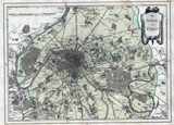
Titre : Die Gegend um PARIS.
Titre forgé : Die // Gegend // um // PARIS.
commentaire : "Die Gegend um PARIS", [Fortsetzungskarte des "Atlas von Frankreich" (Nr. 5); Abschnitt St. Cloud - Noisy le Grand, St. Denis - Sceaux [heute: Paris und Vororte]; Département Seine (Paris, violett) und Distrikte Bourg la Reine (grün) und St. Denis (gelb)]. Franz Joh[ann] Jos[eph] von Reilly (Verfasser). Ignaz Kühn (Stecher), von Reilly'sches geographisches Verschleißkomtoir (Eigenverlag), Berken (Texter), Christian Trummer (Stecher).
description :
caractéristiques du plan
taille : 36,5 x 27 cm echelle : 75000
feuille : echelle recalculée : 70000
type du plan : nature du plan :
prix à l achat : orientation : 0 déformation :
rotation x : 1 rotation y : 0
ecart type : 168 position moyenne : 238
créateurs du plan
éditeur : imprimeur :
lieu édition : graveur :
écriture : auttrait :
libraire : topographie :
lithographie : auteur ouvrage :
nom ouvrage : Atlas von Frankreich
source et localisation
source : Landesarchiv Baden-Württemberg web source :
inv. source : GA 105 Nr. 181 6 Typo I : 403b
inv. Boutier : Typo II : A
inv. Vallée : genre :
inv. BnF : stockage :
inv. BHVP : support :
notice : support II :
longévité, copie et filiation
longévité : début - fin 1806
duree de vie :
filiation :
copie :
reprise :
possession : 0
urbanisme
information autour du plan
nom rue
index monument
nomenclature
vignette
plan situation
iconographie
contexte historique
contexte archéologique
autre localisation
Plan du même auteur
Reilly, Franz Johann Joseph von

1806

Bavarian State Library Die Gegend um Paris 36 x 27cm
Plan avec le même titre
Die Gegend um Paris.

1816

Laugart swaen 18.7 x 27.6 cm